 AT approach trail
3 km
A proper stage setting experience for the A.T. 8.5 miles from the visitors center,...
AT approach trail
3 km
A proper stage setting experience for the A.T. 8.5 miles from the visitors center,... Len Foote Hike Inn
3 km
Great, family friendly place tucked away in the woods! Reserve your spot early, becau...
Len Foote Hike Inn
3 km
Great, family friendly place tucked away in the woods! Reserve your spot early, becau...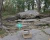 Southern Terminus of the Appalachian Trail
7 km
It's a nice hike with a little up and down but not too bad. Go in early spring and yo...
Southern Terminus of the Appalachian Trail
7 km
It's a nice hike with a little up and down but not too bad. Go in early spring and yo... Gooch Gap
20 km
Easy access by road; Suches just a couple miles up the road and close to Dahlonega.
...
Gooch Gap
20 km
Easy access by road; Suches just a couple miles up the road and close to Dahlonega.
... Chattahoochee National Forest
23 km
Great for a much needed day of rest and relaxation! A true diamond in the rough. Supe...
Chattahoochee National Forest
23 km
Great for a much needed day of rest and relaxation! A true diamond in the rough. Supe...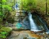 Fall Branch Falls
24 km
Barely anyone there in mid March so it was like having the beautiful falls to ourselv...
Fall Branch Falls
24 km
Barely anyone there in mid March so it was like having the beautiful falls to ourselv... Woody Gap / Appalachian Trail
24 km
Well that's a pretty typical Georgia shelter with all the amenities, and lack of amen...
Woody Gap / Appalachian Trail
24 km
Well that's a pretty typical Georgia shelter with all the amenities, and lack of amen... Boulder Falls Park and Hiking Trail
31 km
Hard to get into private community. Trails are marked and well kept. Trails are clos...
Boulder Falls Park and Hiking Trail
31 km
Hard to get into private community. Trails are marked and well kept. Trails are clos...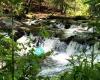 Tumbling Waters Trail
35 km
Fairly easy trail. Just goes out to some rapids where there is a bridge and 2 overloo...
Tumbling Waters Trail
35 km
Fairly easy trail. Just goes out to some rapids where there is a bridge and 2 overloo...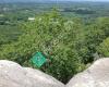 Indian Seats At Sawnee
37 km
I typically hike/run up to the Indian Seats a few times a week. It's really a great a...
Indian Seats At Sawnee
37 km
I typically hike/run up to the Indian Seats a few times a week. It's really a great a... Reinhardt Biking & Hiking Trails
40 km
This is a trail system from beginner to advanced. They are labeled by number so it ea...
Reinhardt Biking & Hiking Trails
40 km
This is a trail system from beginner to advanced. They are labeled by number so it ea... Bear Creek Trail
41 km
Pinhoti trail is awesome, but bear creek miles 5-7 were my favorite. Ride up pinhoti ...
Bear Creek Trail
41 km
Pinhoti trail is awesome, but bear creek miles 5-7 were my favorite. Ride up pinhoti ...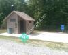 Garland Mountain Horse & Hiking Trails
42 km
The vistas were not expansive, but the trails were well maintained and the early morn...
Garland Mountain Horse & Hiking Trails
42 km
The vistas were not expansive, but the trails were well maintained and the early morn...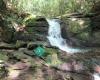 Raven Cliff Falls Trail
43 km
Length: 4.9 Miles
Difficulty: Easy/Moderate. Slight elevation to the end, very manag...
Raven Cliff Falls Trail
43 km
Length: 4.9 Miles
Difficulty: Easy/Moderate. Slight elevation to the end, very manag...to add Amicalola Falls State Park map to your website;